- Diagram of atmospheric absorption of radiation ranging from ultraviolet to thermal infrared. By Don Garlick.
Yes, by simply learning how to interpret available data. The best window into tomorrow's weather is a movie which compresses several hours of satellite-observations into a few seconds: Google "Eureka Weather" and click Current Conditions — East Pacific — Infrared — Loop. After some experience you will be able to reasonably forecast our weather by extrapolating those satellite observations. For precipitation within the next few hours, click Doppler Radar. The following is an introduction to the science behind these sophisticated tools.
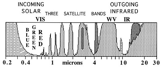
The diagram plots the atmospheric absorption of radiation ranging from ultraviolet (wavelength < 0.4 microns) through visible light (0.4-0.7 microns) and reflected infrared (0.7-3 microns) to thermal infrared (wavelength > 3 microns). The UV absorption is due to ozone. Most of the rest is due to water vapor, excepting those bands shown darker which are due to carbon dioxide. Absorption near 13 microns is of global warming concern.
A geostationary satellite 35,786 km above the equator detects radiation at a variety of wavelengths. One detector near 0.7 microns provides the positive "VIS" image composed of reflected visible sunlight. One near 11 microns yields the negative "IR" image. It is centered on an atmospheric window which transmits thermal infrared energy from the Earth's surface, providing clouds are absent. When clouds are present, their cool tops radiate less energy (lighter tones in the negative image). When storm clouds reach very cold altitudes, the IR image is enhanced with false colors. A detector near 7 microns cannot see the Earth's surface because of intervening water vapor. However, when the atmosphere is drier it detects thermal radiation from lower warmer air. This detector yields the water vapor "WV" image (also negative). The IR and WV images are produced day and night. But don't let them keep you awake.
Rain-detecting Doppler radar is next-week's topic.

Comments