- Flickr user MiguelVieira
- Western Azalea
For most of the year, I seem to be oblivious to the power of flowers to brighten up a room or a relationship. Just ask my wife, Amy. But for a couple of months, about the time winter limps on toward the southern hemisphere and spring begins to assert herself (yes, I do think that if seasons had genders, spring would indeed be female), I become enchanted by the awakening of the land and the arrival of spring flowers.
When the wild radish and mustard plants turn the median along 101 between Arcata and Eureka awash with color, it signals the beginning of Rees' flower season. Those delicate lavenders, yellows and whites that shake as the winds pulse across the bay remind me of Ralph Waldo Emerson's observation, "The earth laughs in flowers." It really is pretty wonderful if you are paying attention.
Our conifer forests, our beaches and dunes, our oak woodlands and mountain prairies all, in turn, burst forth. If flowers had voices, April and May would be far too raucous to ignore let alone sleep. With some help from real wildflower experts like Gisela Rohde and Carol Ralph, and some field testing with my agreeable pal, Tom, I have picked a handful of Humboldt County walks to get you out to hear the choirs coming to life this spring.
For those who know my reputation for turning walks into forced marches, rest assured that these are truly modest outings accessible to most. The focus should be on soaking up the setting and the flowers, not dressing blisters or calling for Search and Rescue. Nonetheless, read the descriptions carefully before you embark on one of these adventures.
1) Azalea Preserve (Kane Road) -- a well-hidden secret
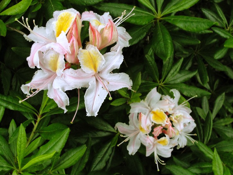
Although there are many places to see azaleas in coastal Humboldt County, the most spectacular concentration is in the Stagecoach Hill Azalea Reserve, not far north of Big Lagoon and just south of Dry Lagoon off Highway 101. Turn east on Kane Road and left at the junction (in about a half mile). There is a weathered sign for the reserve there. The final stretch is on a poorly maintained gravel road that will take you to a rather undefined parking area in a grove of Sitka spruce. It all adds to the sense that you have happened upon some place special. The 40-acre parcel has a modest network of trails that take you through a dense stand of spruce before emerging onto a Western azalea-covered hillside with spectacular vistas out over the ocean to the west. If you time it right, generally in May through early June, you will be treated to a diversity of colors, flower sizes and shapes.
Length: Perhaps a mile if you do a couple loops; Difficulty: Little elevation gain but the trail has uneven tread; Best time for azaleas: Generally May -- early June.
2) Ma'le'l Dunes Cooperative Management Area and the Humboldt Coastal Nature Center (Manila) -- delicate and endangered beauty
Humboldt County's beaches and dunes are home to two federally listed endangered plant species: the Humboldt Bay wallflower and the diminutive beach layia. There is no better place to see the yellow flowers of the wallflower (which could be gone by May) or the sand verbena, the pink and white blossoms of the beach pea, the beach buckwheat, or the ubiquitous beach strawberry than on one of the guided walks offered by the Friends of the Dunes. There are several access points. The unique Stamps House, on Stamps Lane in Manila, serves as the visitor's center for the Coastal Nature Center and provides convenient entrée to a series of short trails through the dune mat and forest. Or Friday through Monday the recently re-opened Ma-le'l Dunes North is accessible from Young Lane, just west of the Mad River Slough Bridge (Highway 255) with a network of trails that provide both dune and forest access and some stunning views. The Ma-l'el South parking area, also off Young Lane, is open seven days a week. Each access point is equipped with restroom facilities. Call the Friends of the Dunes for guided walk information at 444-1397.
Length: Design your route to suit your time and stamina. My favorite is a five-mile loop that begins and ends at the Nature Center and includes the Ma-le'l North Dunes; Difficulty: Little elevation gain but the soft sand in places can be difficult; Best Time for Humboldt Bay wallflower and beach layia blooms: March to early May for the wallflower; the subtle layia blooms a little later.
Alternative Beach Options: Consider the short walk out to the dunes north of the mouth of the Eel River from the south side of Table Bluff. The Ocean Ranch unit of the Eel River Wildlife Area has a signed parking area. Or, for the more ambitious, driving the "Wildcat" (the Ferndale-Petrolia road) is an amazing springtime flower adventure with some limited beach access.
3) Brown Creek Loop (Prairie Creek Redwoods State Park) -- the deep redwood forest
For a sense of humility, reverence, and peace, old growth redwood forests have no equal. As John Steinbeck observed, redwoods "are not like any trees we know; they are ambassadors from another time." The trailhead for this walk is just under three miles from the south end of the Newton B. Drury Parkway (east side of the road). The route follows the Brown Creek Trail to its intersection with the Rhododendron Trail (1.4 miles) where you take a right turn, cross Brown Creek and follow the Rhododendron Trail to the South Fork Trail (1.2 miles). Complete the loop with another right turn on the South Fork Trail. If you are lucky there may be some late trillium, but more certainly redwood violet, sorrel, yellow-orange tiger lily, and the iconic flower of the redwood forests: rhododendron. Redwood National and State Parks are filled with a network of trails that provide access to an abundance of deep forest flora, and it is difficult to go wrong with your choice of paths. Local authors, Jerry and Gisela Rohde, have written an excellent resource, Best Short Hikes in Redwood National and State Parks (Mountaineers, 2004).
Length: 3 1/2 miles; Difficulty: Moderate -- 600 feet of elevation gain; Best Time: Trillium are mostly gone by April but May and June tend to best for rhododendron.
An alternative: Many of us forget nearby Sequoia Park and Sequoia Park Garden. While the park itself is host to native redwood forest flowers and plants, the half-acre garden features a rich assortment of non-native dahlias, day lilies, fuchsias and poppies, as well as summer annuals.
4) Kneeland Airport -- road walking through the oak woodlands
Unfortunately for wildflower enthusiasts, most of our inland prairies and oak woodlands are on private land. For that reason, unless you have connections, access is limited to county roads. Spring generally comes a little later to the high country but traffic rarely does. So there are some wonderful road walks that are surprisingly peaceful. There is nothing more pleasant than taking a stroll along Mountain View Road southeast from Kneeland Airport on a warm, spring day. Soak up the panoramic views and appreciate the flowers in the meadows that cascade down the hillsides.
Another option would be to road walk south of the Fruitland area, after a rambling drive that begins on the Avenue of the Giants near Myers Flat. At milepost 10.5 go east on Elk Creek Road, which joins the Dyerville Loop Road. Some of the best walks are about 14 miles south of Fruitland. Initially known as Elk Prairie, Fruitland was settled by immigrants from the Netherlands who planted orchards. Now vineyards occupy the ridge top. The road itself follows the historic mail route from Sonoma County (circa 1850s).
Length: Design your route to suit your time and stamina; Difficulty: Once you are up at Kneeland Airport or south of Fruitland, the routes are relatively flat; Best time for flowers: May and June, depending on weather.
An alternative: I really like Lyons Ranch and Dolason Prairie because the trails are on National Park land and offer a stunning perspective on Redwood Valley far, far below. For years, Dolason Prairie (trailhead is 11.4 miles up Bald Hills Road from 101) and Lyons Ranch (17 miles up Bald Hills Road) were home to herds of sheep owned by the extended Lyons family, whose four ranches at one time stretched across 10 miles of the Bald Hills. The Lyons Ranch trail loop is a relatively strenuous 4½ mile trip that includes the remnants of one of the homesteads. The Dolason Prairie walk can be extended considerably, but the first 1.3 miles descends through extensive grasslands, abundant with spectacular views, to an old sheep shed which makes a reasonable turnaround point.

Comments