News Blog
Red Salmon Complex and Slater-Devil Fire Updates
- Red Salmon Complex Facebook
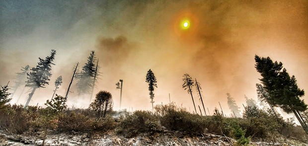
Firefighters are continuing with structural defense work in all active fire areas and burn out operations using drones in the Knownothing Creek area.
Today's report states that upcoming weather is a critical component for firing/burn-out operations. With a high-pressure system moving into some of the areas, the fire will receive between 0.1 to 0.2 inches of rainfall.
A temporary flight restriction is placed in the area Northeast of Orleans, along with an evacuation warning for Forks of Salmon. The Klamath and Six Rivers National Forests are still closed.
Slater-Devil Fire: The Slater fire is at 150,956 and 24 percent contained. The Devil fire is at 7,784 acres with 18 percent contained.
Firefighters are continuing to make good progress to hold and improve containment lines, reads today's update.
At the Slater fire north zone, crews are working to keep the fire from growing. Operations today will focus on constructing a line between Knopki Creek and Sanger Lake, and on Highway 199.
In the south zone, crews will continue with direct line construction north of Thompson Creek and will complete burnout operations to remove unburned fuel between indirect containment lines and the main fire.
See related PDF Red_Salmon_Complex_UPDATE_9-24-2020_Final.pdf
Summary
Winds throughout the valley were a good test for line along the west side of the fire. Isolated interior islands of fuel burned as they were exposed to gusty southwest winds. The Slater fire is 150,956 acres and 24 percent contained. The Devil fire is 7,784 acres and remains 18 percent contained. Firefighters continue to make good progress holding and improving containment lines on both fires. UAS (drones) were used for reconnaissance flights over the fire today to gather information for planning future operations. Cooler temperatures and rain showers are forecast for today.
Slater Fire
North Zone
Crews continue to hold and improve existing containment lines. They are working close to the fire line to keep the fire from growing. Operations today will focus on constructing line between Knopki Creek and Sanger Lake.
The fire came up to the dozer line near Monkey Creek Ridge and is holding. Helicopters assisted crews by dropping water on the fire until winds were too high.
Crews continue to hold and improve the fire line along Highway 199, as well as north and east toward the Browntown area. High afternoon winds caused a spot fire over the line in the Eight Spur Gulch area; however, crews caught it at 20 acres. On the northeast side of the fire near Oregon Caves National Monument crews worked raking out existing trails. The Sucker Creek area saw little new activity.
South Zone
Mop up continues in and around the communities of Happy Camp and Indian Creek. Crews will continue with direct line construction north of Thompson Creek. When conditions allow, crews will complete burnout operations to remove unburned fuel between indirect containment lines and the main fire. Fire progression to the southwest and west has slowed as the fire burns into the Natchez Fire scar.
Devil Fire: Crews on the southwest corner of the fire were able to tie handline down into the creek drainage. The fire remains south of the 1040 Road and is holding to the west of the Butte Fork Trail. An additional crew was assigned and working on the southwest edge of the fire.
Weather: Rain, cooler temperatures and higher relative humidity are forecast for today. Last night the Slater Fire received the following amounts of precipitation: .7 inches on the west side, .4 inches through the center and north, and .2 inches on the east. The Devil Fire received a trace of rain on the north and none on the south.
Evacuations
Josephine County evacuation levels remain the same. For more information, visit the Josephine County Sheriff’s Office website. Evacuation information is available at 541-474-5305 (8 a.m. – 8 p.m.) or: www.facebook.com/josephinecountyEM, www.co.josephine.or.us/fire, or www.rvem.org.
Siskiyou County evacuation information is available at (530) 841-2900 or online at: www.facebook.com/SiskiyouCountySheriff/.
Del Norte County evacuation information is available at (707) 464-7213 or online at: www.facebook.com/DelNorteOfficeOfEmergencyServices and
www.preparedelnorte.com/.
Closures: The USDA Forest Service Pacific Southwest Region has extended the Regional Order temporarily closing nine national forests in California, including the Six Rivers and Klamath (including the part in Oregon) National Forests. This decision will continue to be reviewed daily with changing fire and weather. The entire region is also under emergency fire restrictions.
Rogue River-Siskiyou National Forest has temporarily closed the Wild Rivers Range District and Siskiyou Mountains Ranger District. Find closure orders and maps at www.fs.usda/gov/alerts/rogue-siskiyou/alerts-notices.
The Bureau of Land Management Medford District temporarily closed many areas of public lands to support fire suppression efforts and to prevent new fire starts. Maps of the closure areas are available on the Bureau of Land Management's website: www.blm.gov/programs/public-safety-and-fire/fire-and-aviation/regional-info/oregon-washington/fire-restrictions.

Comments