News Blog
It was a wet and record-setting weekend.
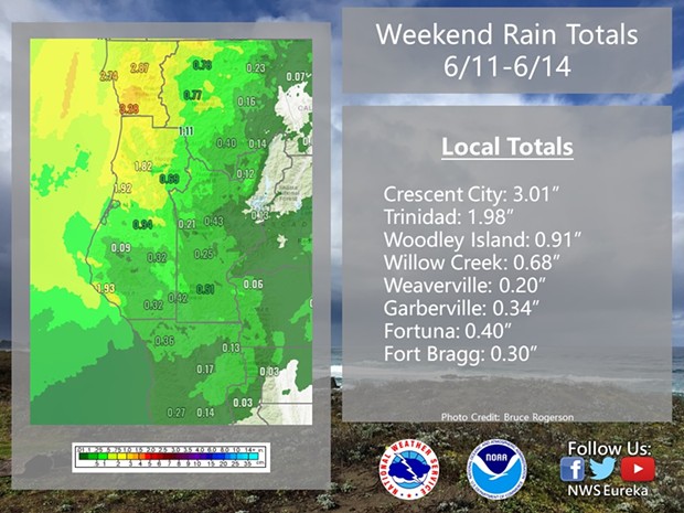
According to the Eureka office of the National Weather Service, two sites hitting precipitations record for June 13, one dating back more than 100 years.
On Sunday, Eureka saw 0.73 inches and Crescent City had 1.94 inches, breaking records set in 1992 (0.62 inches) and 1907 (0.63 inches), respectively.
Find the four-day rain totals below:
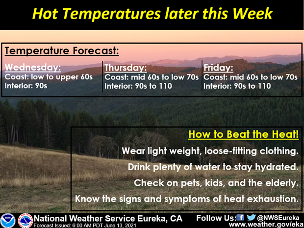
 Now, according to NWS, warmer is weather is on the way due to high pressure over the Southern Rockies that will head to California this week.
According to the Eureka office of the National Weather Service, two sites hitting precipitations record for June 13, one dating back more than 100 years.
On Sunday, Eureka saw 0.73 inches and Crescent City had 1.94 inches, breaking records set in 1992 (0.62 inches) and 1907 (0.63 inches), respectively.
Find the four-day rain totals below:
"Temperatures will be on the increase across the interior as result, with highs in the 90s starting on Wednesday for portions of the interior," the NWS states, noting the hottest temperatures are expected on Thursday and Friday, especially in the areas of Ukiah, Clear Lake, Covelo, and Weaverville. "The heat will linger into the weekend, but there will be some very modest decrease in temperatures on Sunday and Monday. Remember to wear light weight and loose-fit clothing, drink plenty of water, check on those around you (especially pets, kids, and the elderly), and know the signs of heat exhaustion."

Comments